Weather
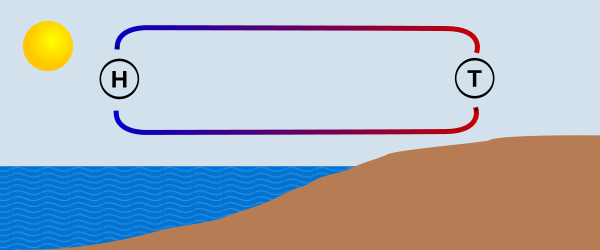
Sea Breeze
Blows during the day from the water onto the land (onshore).
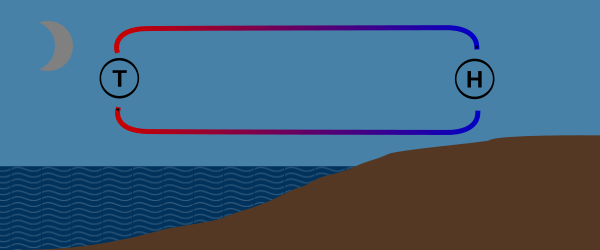
Land Breeze
Blows at night from the land onto the water (offshore).
Thunderstorms
Heat Thunderstorm
Heat thunderstorms form during prolonged high-pressure conditions and bring strong thermal winds. When the land warms up significantly, sea breezes carry large amounts of moisture into the upper layers of the atmosphere, where it condenses and forms thunderclouds (cumulonimbus). This type of thunderstorm is usually limited to a specific region but can produce gusty and strong winds. A particular danger is that the wind dies down just before the storm breaks and then turns through 180°.
Frontal Thunderstorm
Frontal thunderstorms form within the cold front of a large-scale low pressure system. The signs of this type of storm are falling atmospheric pressure and impressively building clouds. These storms usually pass within less than half an hour and can bring rain and hail showers as well as dangerous wind gusts with wind speeds of 75 to 112 km/h.
Storm Warning Service
Many lakes and coastal areas operate orange flashing storm warning beacons. Where present, they are usually arranged so that at least one beacon is visible from any point on the water.
Strong wind warning: 40 flashes per minute
Peak gusts between 39 km/h and 61 km/h.
Recommended actions: reef the sails, put on a life jacket, head for a harbour or sheltered shore.
Storm warning: 90 flashes per minute
Peak gusts above 62 km/h.
Recommended actions: head for a harbour or wind-sheltered shore.